| Maryborough Queensland—Legislative Assembly | |||||||||||||||
|---|---|---|---|---|---|---|---|---|---|---|---|---|---|---|---|
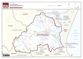 Electoral map of Maryborough 2017 | |||||||||||||||
| State | Queensland | ||||||||||||||
| Created | 1865 | ||||||||||||||
| MP | Bruce Saunders | ||||||||||||||
| Party | Labor | ||||||||||||||
| Namesake | Maryborough | ||||||||||||||
| Electors | 38,267 (2020) | ||||||||||||||
| Area | 4,705 km2 (1,816.6 sq mi) | ||||||||||||||
| Demographic | Provincial | ||||||||||||||
| Coordinates | 25°39′S 152°30′E / 25.650°S 152.500°E | ||||||||||||||
| |||||||||||||||
&sq=Qlik&lang=&file=File:QLD_-_Maryborough_2008.png)
Maryborough is an electoral district of the Legislative Assembly in the Australian state of Queensland.
The district is centred on the regional city of Maryborough and takes in other surrounding communities.