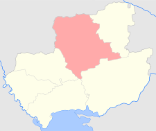
Elisavetgrad uezd
Елисаветградскій уѣздъ | |
|---|---|
 Location in the Kherson Governorate | |
| Country | Russian Empire |
| Governorate | Kherson |
| Established | 1776 and 1865 |
| Abolished | 1828 and 1923 |
| Capital | Elisavetgrad |
| Area | |
| • Total | 15,866.86 km2 (6,126.23 sq mi) |
| Population (1897) | |
| • Total | 613,283 |
| • Density | 39/km2 (100/sq mi) |
| • Urban | 17.57% |
| • Rural | 82.43% |
The Elisavetgrad uezd[a] was a county (uezd) of the Kherson Governorate of the Russian Empire, with its administrative center in Yelisavetgrad (modern Kropyvnytskyi). It bordered the Zvenigorodka and Chigirin uezds of the Kiev Governorate to the north, the Aleksandriya uezd to the east, the Kherson uezd to the south, and the Ananev uezd to the west. The uezd corresponded to Kirovohrad and Mykolaiv Oblasts. Most of the land was owned by the noble Skarzynski family until 1909.[1]
Cite error: There are <ref group=lower-alpha> tags or {{efn}} templates on this page, but the references will not show without a {{reflist|group=lower-alpha}} template or {{notelist}} template (see the help page).
