| Elizabeth Bay Sydney, New South Wales | |||||||||||||||
|---|---|---|---|---|---|---|---|---|---|---|---|---|---|---|---|
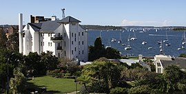
 View from Elizabeth Bay House | |||||||||||||||
 | |||||||||||||||
| Population | 4,878 (SAL 2021)[1] | ||||||||||||||
| • Density | 16,493.3/km2 (42,717/sq mi) | ||||||||||||||
| Postcode(s) | 2011 | ||||||||||||||
| Elevation | 50 m (164 ft) | ||||||||||||||
| Area | 0.3 km2 (0.1 sq mi) | ||||||||||||||
| Location | 2 km (1 mi) E of Sydney CBD | ||||||||||||||
| LGA(s) | City of Sydney | ||||||||||||||
| State electorate(s) | Sydney | ||||||||||||||
| Federal division(s) | Wentworth | ||||||||||||||
| |||||||||||||||
Elizabeth Bay is a harbourside inner city suburb in the Eastern suburbs of Sydney, in the state of New South Wales, Australia. Elizabeth Bay is located three kilometres east of the Sydney central business district and is part of the local government area of the City of Sydney.
The suburb of Elizabeth Bay takes its name from the bay on Sydney Harbour. Macleay Point separates Elizabeth Bay from Rushcutters Bay. The suburb of Elizabeth Bay is surrounded by the suburbs of Rushcutters Bay and Potts Point. Kings Cross is a locality on the south-western border and Garden Island is a locality, to the north.
- ^ Australian Bureau of Statistics (28 June 2022). "Elizabeth Bay (suburb and locality)". Australian Census 2021 QuickStats. Retrieved 28 June 2022.