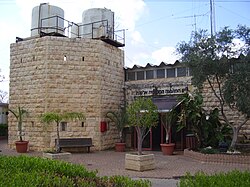
Elkana
| |
|---|---|
Local council (from 1981) | |
| Hebrew transcription(s) | |
| • ISO 259 | ʔelqana |
 | |
| Coordinates: 32°6′35.99″N 35°2′3.48″E / 32.1099972°N 35.0343000°E | |
| Region | West Bank |
| District | Judea and Samaria Area |
| Founded | 1977 |
| Government | |
| • Head of Municipality | Asaf Mintzer |
| Area | |
| • Total | 1,148 dunams (1.148 km2 or 284 acres) |
| Population (2022)[1] | |
| • Total | 4,301 |
| • Density | 3,700/km2 (9,700/sq mi) |
| Name meaning | Named after Elkanah |
Elkana or Elqana (Hebrew: אֶלְקָנָה) is an Israeli settlement and local council in the north-western Samarian hills in the West Bank, located 3.1 km to the east of the Green Line and the city of Rosh HaAyin.[2] It was founded in 1977 by a group from Gush Emunim of religious and non-religious Jews, and by July 2020 it had a population of 3858.[3]
Israeli settlements in the West Bank are considered illegal under international law, but the Israeli government disputes this.[4][5]
- ^ "Regional Statistics". Israel Central Bureau of Statistics. Retrieved 21 March 2024.
- ^ Lands Authority first published tenders for the new homes West Bank settlement of Elkana in November of 2013 - Retrieved 5 September 2014
- ^ "נתונים סטטיסטיים". www.btl.gov.il. Retrieved 2020-09-08.
- ^ "The Geneva Convention". BBC News. 10 December 2009. Retrieved 27 November 2010.
- ^ "Israel announces plans for 1,400 new settlement homes". BBC. 10 January 2014.
The settlements are considered illegal under international law, though Israel disputes this...Israel's housing ministry issued tenders for the construction of 801 housing units in West Bank settlements, including Efrat, Elkana and Emanuel, and 600 in Ramat Shlomo in East Jerusalem.
