Elkhart County | |
|---|---|
 Elkhart County courthouse in Goshen, Indiana | |
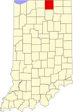
 Location within the U.S. state of Indiana | |
 Indiana's location within the U.S. | |
| Coordinates: 41°36′N 85°52′W / 41.6°N 85.86°W | |
| Country | |
| State | |
| Founded | April 1, 1830 |
| Seat | Goshen |
| Largest city | Elkhart |
| Area | |
• Total | 467.97 sq mi (1,212.0 km2) |
| • Land | 463.17 sq mi (1,199.6 km2) |
| • Water | 4.80 sq mi (12.4 km2) 1.03% |
| Population (2020) | |
• Total | 207,047 |
• Estimate (2023) | 206,409 |
| • Density | 440/sq mi (170/km2) |
| Time zone | UTC−5 (Eastern) |
| • Summer (DST) | UTC−4 (EDT) |
| Congressional district | 2nd |
| Website | www |
| Indiana county number 20 | |
Elkhart County is a county located in the U.S. state of Indiana. As of 2020[update], the county's population was 207,047.[1] The county seat is Goshen.[2] Elkhart County is part of the Elkhart-Goshen Metropolitan Statistical Area, which in turn is part of the South Bend-Elkhart-Mishawaka Combined Statistical Area. It is also considered part of the broader region of Northern Indiana known as Michiana, and is 20 miles (32 km) east of South Bend, Indiana, 110 miles (180 km) east of Chicago, Illinois, and 150 miles (240 km) north of Indianapolis, Indiana. The area is referred to by locals as the recreation vehicle (RV) capital of the world and is known for its sizable Amish and Old Order Mennonite population.[3]
- ^ "2020 Population and Housing State Data". Census.gov.
- ^ "Find a County". National Association of Counties. Archived from the original on May 31, 2011. Retrieved June 7, 2011.
- ^ "RV Capital: Elkhart Indiana". Archived from the original on October 22, 2012. Retrieved July 24, 2008.