This article needs additional citations for verification. (December 2009) |
| Elkhorn River[1] | |
|---|---|
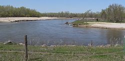
 The Elkhorn River in Antelope County, April 2010 | |
| Physical characteristics | |
| Source | |
| • location | Confluence of North Fork and South Fork |
| • coordinates | 42°36′36″N 099°11′00″W / 42.61000°N 99.18333°W |
| • elevation | 2,162 ft (659 m) |
| Mouth | |
• location | Confluence with Platte |
• coordinates | 41°07′12″N 096°18′42″W / 41.12000°N 96.31167°W |
• elevation | 1,070 ft (330 m)[1] |
| Length | 290 mi (470 km)[1] |
| Discharge | |
| • location | near Waterloo |
| • average | 1,529 cu ft/s (43.3 m3/s)[2] |
| Basin features | |
| Progression | Platte—Missouri—Mississippi |
The Elkhorn River is a river in northeastern Nebraska, United States,[1] that originates in the eastern Sandhills and is one of the largest tributaries of the Platte River, flowing 290 miles (470 km)[3] and joining the Platte just southwest of Omaha, approximately 1 mile (1.6 km) south and 3 miles (4.8 km) west of Gretna.
Located in northeast and north-central Nebraska, the Elkhorn River basin encompasses approximately 7,000 square miles (18,000 km2). The Elkhorn has several tributaries, including its own North and South forks, Logan Creek Dredge, Rock Creek and Maple Creek.
- ^ a b c d U.S. Geological Survey Geographic Names Information System: Elkhorn River
- ^ "USGS Surface Water data for Nebraska: USGS Surface-Water Annual Statistics".
- ^ "The National Map" (Map). viewer.nationalmap.gov. United States Geological Survey. Archived from the original on 29 March 2012. Retrieved 10 Feb 2011 – via Wayback Machine.
