| Ellsworth Mountains | |
|---|---|
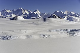
 The central part of Ellsworth Mountains with Mount Tyree, Mount Shinn and Mount Vinson; Nimitz Glacier in the foreground | |
| Highest point | |
| Peak | Mount Vinson |
| Elevation | 4,892 m (16,050 ft) |
| Coordinates | 78°31′31.74″S 85°37′01.73″W / 78.5254833°S 85.6171472°W |
| Dimensions | |
| Length | 360 km (220 mi) NNW-SSE |
| Width | 48 km (30 mi) WE |
| Geography | |
| Continent | Antarctica |
| Land | Ellsworth Land |
| Range coordinates | 78°45′S 85°00′W / 78.750°S 85.000°W[1] |
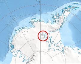
The Ellsworth Mountains are the highest mountain ranges in Antarctica, forming a 350 km (217 mi) long and 48 km (30 mi) wide chain of mountains in a north to south configuration on the western margin of the Ronne Ice Shelf in Marie Byrd Land. They are bisected by Minnesota Glacier to form the Sentinel Range to the north and the Heritage Range to the south. The former is by far the higher and more spectacular with Mount Vinson (4,892 meters (16,050 ft)) constituting the highest point on the continent.[1][2] The mountains are located within the Chilean Antarctic territorial claim but outside of the Argentinian and British ones.
- ^ a b "Ellsworth Mountains". Geographic Names Information System. United States Geological Survey, United States Department of the Interior. Retrieved 6 May 2004.
- ^ Bockheim, J.G., Schaefer, C.E., 2015. Soils of Ellsworth Land, the Ellsworth Mountains. In: Bockheim, J.G. (Ed.), The Soils of Antarctica. World Soils Book Series, Springer, Switzerland, pp. 169–181.

