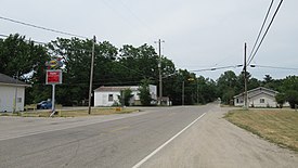
Elm Hall, Michigan | |
|---|---|
 Intersection of Van Buren and Lumberjack | |
| Coordinates: 43°21′54″N 84°50′07″W / 43.36500°N 84.83528°W | |
| Country | United States |
| State | Michigan |
| County | Gratiot |
| Township | Sumner |
| Settled | 1855 |
| Platted | 1863 |
| Area | |
| • Total | 1.41 sq mi (3.65 km2) |
| • Land | 1.40 sq mi (3.63 km2) |
| • Water | 0.01 sq mi (0.03 km2) |
| Elevation | 797 ft (243 m) |
| Population | |
| • Total | 279 |
| • Density | 199.29/sq mi (76.95/km2) |
| Time zone | UTC-5 (Eastern (EST)) |
| • Summer (DST) | UTC-4 (EDT) |
| ZIP code(s) | 48830 48877 (Riverdale) |
| Area code | 989 |
| GNIS feature ID | 625508[3] |
Elm Hall is an unincorporated community and census-designated place (CDP) in Gratiot County in the U.S. state of Michigan.[3] The CDP had a population of 279 at the 2020 census.[2] The community is located within Sumner Township.
As an unincorporated community, Elm Hall has no legal autonomy of its own but does have its own post office with the 48830 ZIP Code.[4][5]
- ^ "2020 U.S. Gazetteer Files". United States Census Bureau. Retrieved May 21, 2022.
- ^ a b United States Census Bureau (January 4, 2023). "Elm Hall CDP, Michigan".
- ^ a b U.S. Geological Survey Geographic Names Information System: Elm Hall, Michigan
- ^ "48830 ZIP Code map" (Map). Google Maps. Retrieved July 24, 2022.
- ^ UnitedStatesZipCodes.org (2022). "ZIP Code 48830: Elm Hall". Retrieved July 24, 2022.

