


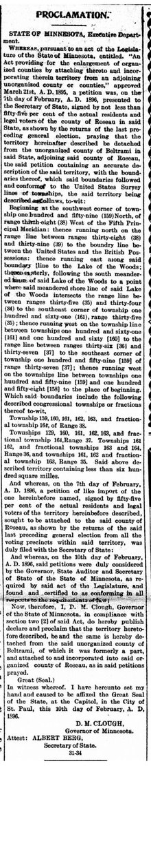
Elm Point, Minnesota, is a small uninhabited[2] cape and a practical exclave of the United States in Lake Township, Roseau County, Minnesota, United States. It is surrounded on the west, south, and east by Lake of the Woods, and on the north by the Canadian First Nation community of Buffalo Point in southeastern Manitoba. Part of Elm Point is privately owned and part of it is state land[3] managed by the Department of Natural Resources as part of the Border Wildlife Management Area.[4] It is located southwest of the much larger exclave known as the Northwest Angle.[5] There is a line of felled trees marking the international border,[6] which runs nominally along the 49th parallel, although in this area it runs slightly to the south[7] due to 19th-century surveying errors.
In addition to Elm Point, there are a few small parcels of land located west of Elm Point but east of the contiguous land mass of Minnesota that extend up to 300 feet (100 m) south of the border, making them U.S. territory. One such area is Buffalo Bay Point.[2]
- ^ Cite error: The named reference
proclamationwas invoked but never defined (see the help page). - ^ a b Frank Jacobs (31 May 2011). "516 – Northwest Angles: One Exclave May Hide Another". Big Think. Archived from the original on 2020-11-12.
- ^ "Roseau County GIS Public Map Service". Roseau County, Minnesota.
- ^ "Border WMA". Wildlife Management Areas. Minnesota Department of Natural Resources.
- ^ "Elm Point, Minnesota". Geographic Names Information System. United States Geological Survey, United States Department of the Interior.
- ^ "Google Maps".
- ^ "Sheet E-58" (PDF). Maps and Coordinates. International Boundary Commission.