| Emi Koussi | |
|---|---|
 Emi Koussi seen from space | |
| Highest point | |
| Elevation | 3,415 m (11,204 ft)[1] |
| Listing | Country high point Ultra |
| Coordinates | 19°47′33″N 18°32′47″E / 19.79250°N 18.54639°E[2] |
| Geography | |
| Location | Chad |
| Parent range | Tibesti Mountains |
| Geology | |
| Rock age | Holocene |
| Mountain type | Pyroclastic shield |
| Last eruption | unknown |
| Climbing | |
| Easiest route | Hike |
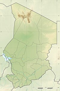
Emi Koussi (also known as Emi Koussou[3]) is a high pyroclastic shield[1] volcano that lies at the southeast end of the Tibesti Mountains in the central Sahara, in the northern Borkou Region of northern Chad. The highest mountain of the Sahara, the volcano is one of several in the Tibesti range, and reaches an elevation of 3,415 metres (11,204 ft), rising 3 km (1.9 mi) above the surrounding sandstone plains. The volcano is 60–70 kilometres (37–43 mi) wide and has a volume of 2,500 cubic kilometres (600 cu mi).
Two nested calderas cap the volcano, the outer one being about 15 by 11 kilometres (9.3 mi × 6.8 mi) in size. Within it on the southeast side is a smaller caldera known as Era Kohor, about 2 kilometres (1.2 mi) wide and 350 metres (1,150 ft) deep. Numerous lava domes, cinder cones, maars, and lava flows are found within the calderas and along the outer flanks of the shield. Era Kohor contains trona deposits, and Emi Koussi has been studied as an analogue of the Martian volcano Elysium Mons. Emi Koussi was active more than one million years ago, but some eruptions may be more recent, and there is ongoing fumarolic and hot spring activity.
- ^ a b Cite error: The named reference
gvpwas invoked but never defined (see the help page). - ^ "Emi Koussi". Peakbagger.com. Retrieved 2021-02-12.
- ^ Hellmich 1972, p. 10.
