Empire | |
|---|---|
| Motto: The Mexican City of the Central Valley | |
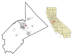
 Location in Stanislaus County and the state of California | |
| Coordinates: 37°38′39″N 120°54′27″W / 37.64417°N 120.90750°W | |
| Country | |
| State | |
| County | Stanislaus |
| Empire City | 1850 |
| Empire | 1896 |
| Area | |
• Total | 1.563 sq mi (4.049 km2) |
| • Land | 1.563 sq mi (4.049 km2) |
| • Water | 0 sq mi (0 km2) 0% |
| Elevation | 118 ft (36 m) |
| Population (2020) | |
• Total | 4,202 |
| • Density | 2,700/sq mi (1,000/km2) |
| Time zone | UTC-8 (Pacific (PST)) |
| • Summer (DST) | UTC-7 (PDT) |
| ZIP code | 95319 |
| Area code | 209 |
| FIPS code | 06-22622 |
| GNIS feature ID | 1658501 |
Empire is a census-designated place (CDP) in Stanislaus County, California, United States. The population was 4,189 at the 2010 census, up from 3,903 at the 2000 census. It is part of the Modesto Metropolitan Statistical Area. Influenced by the Mexican culture, Empire is agriculturally active, and is home to the new Empire Community Park.