| Empire Mine State Historic Park | |
|---|---|
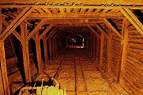
 View along the main drift at Empire Mine | |
| Location | Nevada County, California, United States |
| Nearest city | Grass Valley, California |
| Coordinates | 39°12′13″N 121°2′34″W / 39.20361°N 121.04278°W |
| Area | 853 acres (345 ha) |
| Established | 1975 |
| Governing body | California Department of Parks and Recreation |
Empire Mine | |
| Area | 777 acres |
| Built | 1896 |
| Architect | Polk, Willis |
| NRHP reference No. | 77000318[1] |
| CHISL No. | 298[2] |
| Added to NRHP | December 09, 1977 |
Empire Mine State Historic Park is a state-protected mine and park in the Sierra Nevada mountains in Grass Valley, California, U.S. The Empire Mine is on the National Register of Historic Places, a federal Historic District, and a California Historical Landmark. Since 1975 California State Parks has administered and maintained the mine as a historic site. The Empire Mine is "one of the oldest, largest, deepest, longest and richest gold mines in California".[3] Between 1850 and its closure in 1956, the Empire Mine produced 5.8 million ounces (165 tons) of gold, extracted from 367 miles (591 km) of underground passages.[4]
- ^ "National Register Information System". National Register of Historic Places. National Park Service. March 13, 2009.
- ^ "Empire Mine". Office of Historic Preservation, California State Parks. Retrieved October 10, 2012.
- ^ "Empire Mine SHP". California State Parks. Archived from the original on December 16, 2011. Retrieved December 16, 2011.
- ^ Forgione, Mary (February 21, 2014). "California: Park scraps gold mine tour after spending $3.5 million". Los Angeles Times. Retrieved May 9, 2016.

