Emporia, Virginia | |
|---|---|
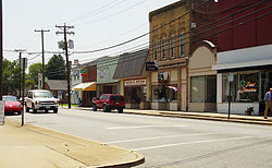
 Downtown Emporia | |
| Nickname: "E-Town" | |
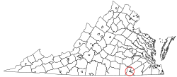
 Location in the Commonwealth of Virginia | |
| Coordinates: 36°41′34″N 77°32′17″W / 36.69278°N 77.53806°W | |
| Country | United States |
| State | Virginia |
| County | Greensville (None after incorporation -Independent city) |
| Chartered | 1967 |
| Government | |
| • Mayor | Carolyn Carey |
| Area | |
• Total | 6.97 sq mi (18.05 km2) |
| • Land | 6.90 sq mi (17.88 km2) |
| • Water | 0.06 sq mi (0.17 km2) |
| Elevation | 128 ft (39 m) |
| Population (2020) | |
• Total | 5,766 |
| • Density | 830/sq mi (320/km2) |
| Time zone | UTC-5 (EST) |
| • Summer (DST) | UTC-4 (EDT) |
| ZIP code | 23847/23867 |
| Area code | 434 |
| FIPS code | 51-25808[2] |
| GNIS feature ID | 1498475[3] |
| Website | ci |
Emporia is an independent city in the Commonwealth of Virginia, surrounded by Greensville County, United States. Emporia and a predecessor town have been the county seat of Greensville County since 1791.[4] As of the 2020 census, the population was 5,766,[5] making it the third-least populous city in Virginia. The Bureau of Economic Analysis combines the city of Emporia with surrounding Greensville County for statistical purposes. The town has become notorious for being a major speed trap.[6]
- ^ "2019 U.S. Gazetteer Files". United States Census Bureau. Retrieved August 7, 2020.
- ^ "U.S. Census website". United States Census Bureau. Retrieved January 31, 2008.
- ^ "US Board on Geographic Names". United States Geological Survey. October 25, 2007. Retrieved January 31, 2008.
- ^ "Find a County". National Association of Counties. Archived from the original on May 31, 2011. Retrieved June 7, 2011.
- ^ "Emporia city, Emporia city, Virginia". United States Census Bureau. Retrieved January 26, 2022.
- ^ Hankerson, Mechelle (September 2, 2019). "Which Virginia localities rely most on traffic fines for revenue?". Virginia Mercury. Retrieved June 20, 2024.
