| Enard Bay | |
|---|---|
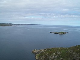
 Green Island and Enard Bay from the mountain Creag na Speirag. | |
| Location | Ross and Cromarty, Scotland |
| Coordinates | 58°05′45″N 5°20′11″W / 58.09583°N 5.33639°W |
| River sources | River Polly |
| Ocean/sea sources | The Minch |
| Basin countries | Scotland |
| Max. length | 7.4 km (4.6 mi) |
| Max. width | 8.85 km (5.50 mi) |
| Islands | Eilean Mòr |
Enard Bay is a large remote tidal coastal embayment, located 10.5 miles northwest of Ullapool, in northwestern Ross and Cromarty,[1] Scottish Highlands in the west coast of Scotland.[2] The mouth of the bay is about 4.5 miles across running from the head of Rubha Mòr peninsula at Rubna Na CòiGeach (English:Ru Coygach) point to Rubna Na Brèige (English:Kirkaig point) to the east.[3]
- ^ William J. Watson (29 November 2012). Ross and Cromarty. Cambridge University Press. pp. 46–. ISBN 978-1-107-68534-5.
- ^ Microsoft; Nokia. "Enard Bay" (Map). Bing Maps. Microsoft. Retrieved 23 March 2017.
- ^ West Coast of Scotland Pilot. J. D. Potter. 1894. p. 413.
