| Enfield Falls Canal | |
|---|---|
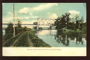
 Windsor Locks Canal and railroad bridge (postcard mailed in 1909) | |
 | |
| Specifications | |
| Length | 5.25 miles (8.45 km) |
| Locks | 1 (north end); 3 (south end) |
| Status | Closed |
| Navigation authority | |
Enfield Falls Canal (Windsor Locks Canal) | |
| Nearest city | Windsor Locks, Connecticut |
| Area | 55 acres (22 ha) |
| Built | 1829 |
| Engineer | Canvass White |
| NRHP reference No. | 76001998[1] |
| Added to NRHP | April 22, 1976 |
| History | |
| Construction began | 1827 |
| Date completed | November 11, 1829 |
| Geography | |
| Start point | 41°59′12″N 72°36′19″W / 41.9866°N 72.6053°W |
| End point | 41°55′01″N 72°37′29″W / 41.9169°N 72.6248°W |
Enfield Falls Canal (commonly known as the Windsor Locks Canal) is a canal that was built to circumvent the shallows at Enfield Falls (or Enfield Rapids) on the Connecticut River, between Hartford, Connecticut and Springfield, Massachusetts. It is situated along the west side of the river, adjacent to the towns of Suffield and Windsor Locks in Hartford County in the state of Connecticut, United States. Windsor Locks is named after the series of locks on the canal.

