Englewood, Florida | |
|---|---|
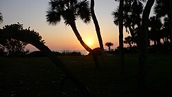
 Sunset from the Manasota Beach Club | |
 Location in Sarasota County and the state of Florida | |
| Coordinates: 26°57′47″N 82°21′7″W / 26.96306°N 82.35194°W | |
| Country | |
| State | |
| Counties | Sarasota, Charlotte |
| Platted | 1896[1] |
| Area | |
• Total | 22.32 sq mi (57.82 km2) |
| • Land | 18.82 sq mi (48.75 km2) |
| • Water | 3.50 sq mi (9.07 km2) |
| Elevation | 10 ft (3 m) |
| Population (2020) | |
• Total | 20,800 |
| • Density | 1,105.03/sq mi (426.65/km2) |
| Time zone | UTC−05:00 (Eastern (EST)) |
| • Summer (DST) | UTC−04:00 (EDT) |
| ZIP Codes | 34223, 34224, 34295 |
| Area code | 941 |
| FIPS code | 12-20825[3] |
| GNIS feature ID | 0282217 |
| [3] | |
Englewood is a census-designated place (CDP) in Charlotte and Sarasota counties in the U.S. state of Florida. As of the 2020 census, it had a population of 20,800, up from 14,863 at the 2010 census. It is part of the North Port-Bradenton-Sarasota, Florida Metropolitan Statistical Area.
- ^ "Englewood's beginnings". Sarasota Herald-Tribune. August 30, 1995. p. 10. Retrieved November 3, 2015.
- ^ "2020 U.S. Gazetteer Files". United States Census Bureau. Retrieved October 31, 2021.
- ^ a b "Englewood". Geographic Names Information System. United States Geological Survey, United States Department of the Interior. October 19, 1979. Retrieved January 17, 2019.