Enrile | |
|---|---|
| Municipality of Enrile | |
 Municipal Hall of Enrile | |
| Nickname: Peanut Capital of the Philippines[1] | |
| Motto(s): Awan Na Matalan, Awan Nga Kalippanan | |
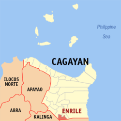
 Map of Cagayan with Enrile highlighted | |
Location within the Philippines | |
| Coordinates: 17°33′44″N 121°42′04″E / 17.5622°N 121.7011°E | |
| Country | Philippines |
| Region | Cagayan Valley |
| Province | Cagayan |
| District | 3rd district |
| Named for | Pasqual Enrile y Alcedo |
| Barangays | 22 (see Barangays) |
| Government | |
| • Type | Sangguniang Bayan |
| • mayor of Enrile[*] | Miguel B. Decena Jr. |
| • Vice Mayor | Christina G. Magbitang |
| • Representative | Joseph "Jojo" L. Lara |
| • Sangguniang Panlalawigan | List |
| • Electorate | 23,072 voters (2022) |
| Area | |
| • Total | 184.50 km2 (71.24 sq mi) |
| Elevation | 56 m (184 ft) |
| Highest elevation | 188 m (617 ft) |
| Lowest elevation | 13 m (43 ft) |
| Population (2020 census)[4] | |
| • Total | 36,705 |
| • Density | 200/km2 (520/sq mi) |
| • Households | 8,235 |
| Economy | |
| • Income class | 3rd municipal income class |
| • Poverty incidence | 11.12 |
| • Revenue | |
| • Assets | |
| • Govt Equity | |
| • Appropriations | |
| • Expenditure | |
| • Obligations | |
| • Liabilities | |
| Service provider | |
| • Electricity | Cagayan 1 Electric Cooperative (CAGELCO 1) |
| Time zone | UTC+8 (PST) |
| ZIP code | 3501 |
| PSGC | |
| IDD : area code | +63 (0)78 |
| Native languages | Ibanag Ilocano Tagalog |
| Lent Culture | Padafung |
| Major religions | Roman Catholic |
| Catholic diocese | Diocese of Tuguegarao |
| Patron saint | Our Lady of Snows |
| Festival | Peanut Festival (Mappalabbet) |
Enrile, officially the Municipality of Enrile (Itawis: Babalay yo Enrile; Ibanag: Ili nat Enrile; Ilocano: Ili ti Enrile; Tagalog: Bayan ng Enrile), is a 3rd class municipality in the province of Cagayan, Philippines. According to the 2020 census, it has a population of 36,705 people.[4]
Enrile lies on the southernmost part of Cagayan, bounded by Sta. Maria, Isabela to the south, by the mighty Cagayan River to the east, by Solana and Tuguegarao to the north, and Rizal, Kalinga to the west.
The town is predominantly an agricultural town where the majority of its population derive their income from farming. It has a land area of 18,451.3 hectares unevenly distributed to the 22-barangays of the municipality. Its main products are rice, corn, peanut, tobacco and vegetables.
Its citizens are called Itawes because they speak the Itawis dialect (locally called Itawit). Ilocanos and Tagalogs have settled at the western barangays and have blended very well in the mainstream of Itawes life.
- ^ "Area of Coverage". ATI in Cagayan Valley. Archived from the original on December 23, 2021. Retrieved December 23, 2021.
- ^ Municipality of Enrile | (DILG)
- ^ "2015 Census of Population, Report No. 3 – Population, Land Area, and Population Density" (PDF). Philippine Statistics Authority. Quezon City, Philippines. August 2016. ISSN 0117-1453. Archived (PDF) from the original on May 25, 2021. Retrieved July 16, 2021.
- ^ a b Census of Population (2020). "Region II (Cagayan Valley)". Total Population by Province, City, Municipality and Barangay. Philippine Statistics Authority. Retrieved July 8, 2021.
- ^ "PSA Releases the 2021 City and Municipal Level Poverty Estimates". Philippine Statistics Authority. April 2, 2024. Retrieved April 28, 2024.
- ^ "Commission on Audit Report - Cagayan". coa.gov.ph. Commission on Audit. Retrieved May 24, 2021.
- ^ "Commission on Audit Report - Cagayan (Enrile)". coa.gov.ph. Commission on Audit. Retrieved May 24, 2021.
- ^ "Commission on Audit Report - Cagayan (Enrile)". Commission on Audit. Retrieved May 24, 2021.
- ^ "COA Report - Enrile, Cagayan". coa.gov.ph. Commission on Audit. Retrieved May 24, 2021.
- ^ "COA Report - Enrile, Cagayan". Retrieved May 24, 2021.
- ^ "COA Report - Enrile, Cagayan". Retrieved May 24, 2021.


