This article needs additional citations for verification. (August 2022) |
Erattupetta | |
|---|---|
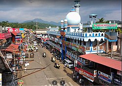
 Central junction, Erattupetta | |
| Coordinates: 9°42′N 76°47′E / 9.7°N 76.78°E | |
| Country | |
| State | Kerala |
| District | Kottayam |
| Government | |
| • Type | Municipality |
| • Municipal Chairperson | Suhara Abdul Khader(IUML) |
| • Municipal Vice Chairman | Muhammad Ilyas (INC) |
| Area | |
• Total | 18.29 km2 (7.06 sq mi) |
| Elevation | 24 m (79 ft) |
| Population (2011)[2] | |
• Total | 34,814 |
| • Density | 1,900/km2 (4,900/sq mi) |
| Languages | |
| • Official | Malayalam, English |
| Time zone | UTC+5:30 (IST) |
| Vehicle registration | KL-35 |
| Literacy | 95% |
| Website | Official website |
Erattupetta (Malayalam pronunciation: [i:ra:tupe:ʈa]) is a municipality[3] in the Kottayam district of Kerala, India. It is located 29 km (18.0 mi) east of the district headquarters in Kottayam and about 133 km (82.6 mi) north of the state capital Thiruvananthapuram. As per the 2011 Indian census, Erattupetta has a population of 34,814 people, and a population density of 1,906/km2 (4,940/sq mi).

