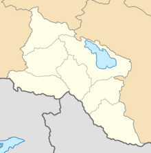
Erivan Governorate
Эриванская губерния | |
|---|---|
 Administrative map of the Erivan Governorate | |
| Country | Russian Empire |
| Viceroyalty | Caucasus |
| Established | 1849 |
| Abolished | 1917 |
| Capital | Erivan (present-day Yerevan) |
| Area | |
• Total | 26,397.11 km2 (10,191.98 sq mi) |
| • Water | 1,416.2 km2 (546.8 sq mi) |
| Highest elevation | 5,137 m (16,854 ft) |
| Population (1916) | |
• Total | 1,120,242 |
| • Density | 42/km2 (110/sq mi) |
| • Urban | 11.83% |
| • Rural | 88.17% |
The Erivan Governorate[a] was a province (guberniya) of the Caucasus Viceroyalty of the Russian Empire, with its centеr in Erivan (present-day Yerevan). Its area was 27,830 sq. kilometеrs,[1] roughly corresponding to what is now most of central Armenia, the Iğdır Province of Turkey, and the Nakhchivan exclave of Azerbaijan. At the end of the 19th century, it bordered the Tiflis Governorate to the north, the Elizavetpol Governorate to the east, the Kars Oblast to the west, and Persia and the Ottoman Empire to the south. Mount Ararat and the fertile Ararat Valley were included in the center of the province.
In 1828, the khanates of Erivan and the Nakhichevan were annexed from Persia by the Russian Empire through the Treaty of Turkmenchay. The newly annexed territories were incorporated into a single administrative unit known as the Armenian Oblast. In 1849, the oblast was reorganized into a governorate.[2]
| History of Armenia |
|---|
 |
| Timeline • Origins • Etymology |
Cite error: There are <ref group=lower-alpha> tags or {{efn}} templates on this page, but the references will not show without a {{reflist|group=lower-alpha}} template or {{notelist}} template (see the help page).
- ^ Brockhaus and Efron Encyclopædia. Erivan Governorate
- ^ Cite error: The named reference
:3was invoked but never defined (see the help page).
