| Irkeshtam Pass | |
|---|---|
 Chinese border post at Erkeshtam | |
| Elevation | 2,950 m (9,678 ft) |
| Traversed by | |
| Location | |
| Range | Pamir Range - Tian Shan |
| Coordinates | 39°41′N 73°55′E / 39.68°N 73.91°E |
 | |
Erkeshtam
| |
|---|---|
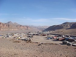
 Trucks waiting to cross into China in the village of Erkeshtam | |
| Country | |
| Region | Osh Region |
| Elevation | 3,005 m (9,859 ft) |
| Time zone | UTC +6 |
Erkeshtam, called Irkeshtam in Chinese and Dungan, or Erkech-Tam in Uyghur and Kyrgyz, is a border crossing between Kyrgyzstan and Xinjiang, China, named after a village on the Kyrgyz side of the border in southern Osh Region. The border crossing is also called Simuhana (斯姆哈纳), after the first settlement on the Chinese side of the border, but Erkeshtam is now the more common name used in both countries.
Erkeshtam is the westernmost border crossing in China. It is one of two border crossings between Kyrgyzstan and China, the other being Torugart, some 165 km (103 mi) to the northeast.[1]

- ^ 克州史志办 (2007-10-05). "伊尔克什坦口岸". www.xjkz.gov.cn (Kizilsu Prefecture Government Website) (in Chinese). Retrieved 2017-02-02.

