Escuminac | |
|---|---|
 Village of Pointe-à-la-Garde in 1927 | |
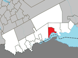
 Location within Avignon RCM | |
| Coordinates: 48°07′N 66°29′W / 48.12°N 66.48°W[1] | |
| Country | Canada |
| Province | Quebec |
| Region | Gaspésie– Îles-de-la-Madeleine |
| RCM | Avignon |
| Settled | 2nd half of 18th century |
| Constituted | October 10, 1907 |
| Government | |
| • Mayor | Robert Bruce Wafer |
| • Federal riding | Gaspésie— Îles-de-la-Madeleine |
| • Prov. riding | Bonaventure |
| Area | |
| • Total | 108.93 km2 (42.06 sq mi) |
| • Land | 108.70 km2 (41.97 sq mi) |
| Population (2021)[3] | |
| • Total | 575 |
| • Density | 5.3/km2 (14/sq mi) |
| • Pop (2016-21) | |
| • Dwellings | 317 |
| Time zone | UTC−5 (EST) |
| • Summer (DST) | UTC−4 (EDT) |
| Postal code(s) | |
| Area code(s) | 418 and 581 |
| Highways | |
| Website | www |
Escuminac is a municipality in Quebec, Canada, on the north shore of the Restigouche River.
In addition to Escuminac itself, the municipality also includes the communities of Escuminac Flats, Fleurant, and Pointe-à-la-Garde.
According to missionary Joseph-Étienne Guinard, Escuminac is a Mi'kmaq word meaning "here are small fruits", originally identifying a point of land jutting into the Restigouche River. But this translation has been disputed as fanciful. It has been spelled in various ways over time, including Semenac, Scamanac, Scaumenac, Escouminac, Scoumenac, and Scouminac.[1]
- ^ a b Cite error: The named reference
toponymiewas invoked but never defined (see the help page). - ^ a b "Répertoire des municipalités: Geographic code 06025". www.mamh.gouv.qc.ca (in French). Ministère des Affaires municipales et de l'Habitation. Retrieved 2024-04-10.
- ^ a b "Escuminac, Quebec (Code 2406025) Census Profile". 2021 census. Government of Canada - Statistics Canada. Retrieved 2024-04-10.
