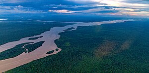
| Essequibo River Río Esequibo | |
|---|---|
 The Essequibo River in Guyana | |
 Map of the Essequibo drainage basin | |
| Location | |
| Country | Guyana |
| Physical characteristics | |
| Source | |
| • location | Acarai Mountains |
| • coordinates | 1°25′2.0532″N 58°59′53.8764″W / 1.417237000°N 58.998299000°W |
| • elevation | 250 m (820 ft) |
| Mouth | Atlantic Ocean |
• coordinates | 7°02′N 58°27′W / 7.033°N 58.450°W |
• elevation | 0 ft (0 m) |
| Length | 1,014 km (630 mi) |
| Basin size | 156,828 km2 (60,552 sq mi) 158,232.7 km2 (61,094.0 sq mi)[1] |
| Discharge | |
| • location | Atlantic Ocean, Guyana (near mouth) |
| • average | (Period: 1971–2000)5,136 m3/s (181,400 cu ft/s)[1] 5,650 m3/s (200,000 cu ft/s)[2] 178 km3/a (5,600 m3/s)[3] |
| Discharge | |
| • location | Bartica (80 km upstream of mouth; Basin size: 154,175 km2 (59,527 sq mi) |
| • average | (Period: 1979–2015)156.24 km3/a (4,951 m3/s)[5]
(Period: 1971–2000)5,043.9 m3/s (178,120 cu ft/s)[1] (Period: 1965–1998)4,100 m3/s (140,000 cu ft/s)[4] |
| • minimum | (Period: 1965–1998)1,850 m3/s (65,000 cu ft/s)[4] |
| • maximum | (Period: 1965–1998)8,700 m3/s (310,000 cu ft/s)[4] |
| Discharge | |
| • location | Plantain Island (Basin size: 66,563 km2 (25,700 sq mi) |
| • average | (Period: 1971–2000)2,316.8 m3/s (81,820 cu ft/s)[1] 2,832 m3/s (100,000 cu ft/s)[6] |
| • minimum | 145 m3/s (5,100 cu ft/s) |
| • maximum | 8,010 m3/s (283,000 cu ft/s) |
| Discharge | |
| • location | Apoteri (Basin size: 22,679.1 km2 (8,756.4 sq mi) |
| • average | (Period: 1971–2000)617.6 m3/s (21,810 cu ft/s)[1] |
| Basin features | |
| River system | Essequibo River |
| Tributaries | |
| • left | Kamoa, Kassikaityu, Kuyuwini, Rupununi, Siparuni, Konawaruk, Potaro, Cuyuni, Supenaam |
| • right | Chodikar |
The Essequibo River (Spanish: Río Esequibo; originally called by Alonso de Ojeda; Río Dulce)[7][8] is the largest river in Guyana, and the largest river between the Orinoco and Amazon. Rising in the Acarai Mountains near the Brazil–Guyana border, the Essequibo flows to the north for 1,014 km (630 mi) through forest and savanna into the Atlantic Ocean. It has a total drainage basin of 156,828 km2 (60,552 sq mi) and an average discharge of 5,650 m3/s (200,000 cu ft/s).
Territory near the river is argued over by Venezuela and Guyana.[9] The river is administered by Guyana after being previously colonized by the British. Historically, Venezuela has claimed the Essequibo River as their most eastern border, though in practice it was under Dutch control.
- ^ a b c d e "Atlantic North Coast".
- ^ "Verkenning effecten Versnelde zeespiegelstijging op dynamiek Westerschelde estuariene systeem" (PDF). 18 Jun 1998.
- ^ Likens, Gene E. (20 May 2010). Biogeochemistry of Inland Waters. Academic Press. ISBN 978-0-12-381997-0.
- ^ a b c Guyana Mangrove-Seawall Engineering Guidance (PDF). 2022.
- ^ "River Basins".
- ^ Faustino, Morales (1999). GEOGRAFÍA FÍSICA DEL TERRITORIO EN RECLAMACIÓN GUYANA ESEQUIBA. Fondo Editorial Humanidades. ISBN 980-00-1617-1.
- ^ Navarrete, Martín Fernández de (1829). Colección de los viages y descubrimientos que hicieron por mar los españoles desde fines del siglo XV: con varios documentos inéditos concernientes á la historia de la marina castellana y de los establecimientos españoles en Indias (in Spanish). Imprenta real.
- ^ Rojas, Juan Fernández de (1828). El Páxaro en La liga: epistola gratulatoria al traductor de La liga de la teologia moderna con la filosofia (in French). en la oficina de Don Benito Cano.
- ^ Ince, Basil. "The Venezuela-Guyana Boundary Dispute in the United Nations". Caribbean Studies.