Etna, Ohio | |
|---|---|
 Township hall at Etna | |
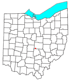
 Location of Etna in Ohio | |
| Coordinates: 39°57′16″N 82°41′16″W / 39.95444°N 82.68778°W | |
| Country | United States |
| State | Ohio |
| County | Licking |
| Township | Etna |
| Area | |
• Total | 0.62 sq mi (1.60 km2) |
| • Land | 0.61 sq mi (1.59 km2) |
| • Water | 3.11 sq mi (0.01 km2) |
| Elevation | 1,070 ft (330 m) |
| Population (2020) | |
• Total | 1,209 |
| • Density | 1,965.85/sq mi (759.11/km2) |
| Time zone | UTC-5 (Eastern (EST)) |
| • Summer (DST) | UTC-4 (EDT) |
| ZIP Code | 43062 (Pataskala) |
| FIPS code | 39-25676[3] |
| GNIS feature ID | 2633229[2] |
Etna (formerly Carthage) is an unincorporated community and census-designated place (CDP) in Licking County, Ohio, United States. As of the 2020 census it had a population of 1,209. It lies at an elevation of 1,069 feet (326 m) at the intersection of U.S. Route 40 and State Route 310.[4] It was listed as a census-designated place in 2010.[5]
- ^ "ArcGIS REST Services Directory". United States Census Bureau. Retrieved September 20, 2022.
- ^ a b U.S. Geological Survey Geographic Names Information System: Etna, Licking County, Ohio
- ^ "U.S. Gazetteer Files: 2019: Places: Ohio". U.S. Census Bureau Geography Division. Retrieved July 17, 2020.
- ^ "Etna, Licking County, Ohio". ACME Mapper. U.S. Geological Survey 7-1/2 minute topographic map series. Retrieved July 17, 2020.
- ^ "Etna Census Designated Place". Geographic Names Information System. United States Geological Survey, United States Department of the Interior.