Eureka Springs, Arkansas | |
|---|---|
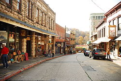
 Spring Street | |
| Nicknames: "Eureka", "Little Switzerland of America", "The Stairstep Town" | |
 Location within Carroll County and Arkansas | |
| Coordinates: 36°24′38″N 93°44′42″W / 36.41056°N 93.74500°W | |
| Country | United States |
| State | Arkansas |
| County | Carroll |
| Incorporated | 1880 |
| Government | |
| • Type | Mayor–council government |
| • Mayor | Butch Berry |
| Area | |
• Total | 6.90 sq mi (17.86 km2) |
| • Land | 6.76 sq mi (17.50 km2) |
| • Water | 0.14 sq mi (0.36 km2) |
| Elevation | 1,421 ft (433 m) |
| Population (2020) | |
• Total | 2,166 |
| • Density | 320.51/sq mi (123.75/km2) |
| Time zone | UTC−6 (CST) |
| • Summer (DST) | UTC−5 (CDT) |
| ZIP Codes | 72631–72632 |
| Area code | 479 |
| FIPS code | 05-22240 |
| GNIS ID | 2403579[2] |
| Website | www |
Eureka Springs is a city in Carroll County, Arkansas, United States, and one of two county seats for the county.[3] It is located in the Ozark Mountains of northwest Arkansas, near the border with Missouri. As of the 2020 census, the city population was 2,166.[4]
In 1970 the entire city, as of its borders at that time, was listed on the National Register of Historic Places as the Eureka Springs Historic District. Eureka Springs has been selected as one of America's Distinctive Destinations by the National Trust for Historic Preservation. Eureka Springs was originally called "The Magic City", "Little Switzerland of the Ozarks", and later the "Stairstep Town" because of its mountainous terrain and the winding, up-and-down paths of its streets and walkways.
It is a tourist destination for its unique character as a Victorian resort, which first attracted visitors to use its then believed healing springs. The city has steep winding streets filled with Victorian-style cottages and manors. The historic commercial downtown of the city has an extensive streetscape of well-preserved Victorian buildings. The buildings are primarily constructed of local stone, built along limestone streets that curve around the hills, and rise and fall with the topography in a five-mile long loop. Some buildings have street-level entrances on more than one floor and other such oddities: the Basin Park Hotel has its front entrances on the floor below first, and a ground-level emergency exit in the back of the building on the fifth floor. The streets wind around the town, with few intersecting at right angles. There are no traffic lights.
- ^ "2020 U.S. Gazetteer Files". United States Census Bureau. Retrieved October 29, 2021.
- ^ a b U.S. Geological Survey Geographic Names Information System: Eureka Springs, Arkansas
- ^ "Find a County". National Association of Counties. Archived from the original on May 31, 2011. Retrieved June 7, 2011.
- ^ "Explore Census Data". data.census.gov. Retrieved December 3, 2021.