| Euxton | |
|---|---|
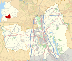
 Euxton lies along the A49 and the A581 roads between Chorley and Leyland. | |
Location within Lancashire | |
| Population | 9,993 (2011 Census) |
| OS grid reference | SD555186 |
| Civil parish |
|
| District | |
| Shire county | |
| Region | |
| Country | England |
| Sovereign state | United Kingdom |
| Post town | CHORLEY |
| Postcode district | PR6,PR7 |
| Dialling code | 01257 |
| Police | Lancashire |
| Fire | Lancashire |
| Ambulance | North West |
| UK Parliament | |
Euxton (/ˈɛkstən/ EKS-tən) is a village and civil parish of the Borough of Chorley, in Lancashire, England. The population of the civil parish as taken at the 2011 census was 9,993,[1] however, the population is now estimated to be around 14,000 due to the increase in housing developments in the village, including the Buckshaw development. The village is situated just to the west of Chorley, and to the south of Clayton-le-Woods.
Euxton is around 2.5 miles from east to west and 2 miles north to south. The village is made up of several areas including Runshaw Moor, Balshaw, Shaw Green, Daisy Hill, Buckshaw, Pincock, Primrose Hill, Glead Hill, Dawbers, Spout Hillock, Culbeck and Pear Tree.
Euxton is served by five primary schools, namely: Balshaw Lane Primary, Primrose Hill Primary, Euxton C of E Primary, Euxton RC Primary and Trinity C of E/Methodist Primary School.
- ^ UK Census (2011). "Local Area Report – Euxton Parish (E04005151)". Nomis. Office for National Statistics. Retrieved 26 March 2021.

