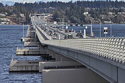
Evergreen Point Floating Bridge | |
|---|---|
 Looking east from the multi-use trail | |
| Coordinates | 47°38′27″N 122°15′33″W / 47.64080°N 122.25926°W |
| Carries | |
| Crosses | Lake Washington |
| Locale | Seattle, Washington |
| Official name | The SR 520 Albert D. Rosellini Evergreen Point Floating Bridge[1] |
| Named for | Albert Rosellini |
| Owner | Washington State Department of Transportation (WSDOT) |
| Characteristics | |
| Design | Pontoon bridge |
| Material | Precast concrete |
| Total length | 7,710 feet (2,350 m) |
| Width | 116 feet (35 m) (at midpoint) |
| Design life | 75 years |
| History | |
| Construction start | 2011 |
| Construction cost | $4.65 billion (project budget)[2] |
| Opened | April 11–25, 2016 |
| Dedicated | April 2, 2016 |
| Replaces | Evergreen Point Floating Bridge (1963–2016) |
| Statistics | |
| Daily traffic | 57,913 (2023) |
| Toll | $1.35–$6.90 |
| Location | |
 | |
The Evergreen Point Floating Bridge, also known as the 520 Bridge and officially the Governor Albert D. Rosellini Bridge, carries Washington State Route 520 across Lake Washington from Seattle to its eastern suburbs. The 7,710-foot-long (2,350 m) floating span is the longest floating bridge in the world, as well as the world's widest measuring 116 feet (35 m) at its midpoint. It is a toll bridge and uses electronic collection.
The bridge opened in April 2016 and replaced original Evergreen Point Floating Bridge at the site, which was 130 feet (40 m) shorter and four lanes wide. The original bridge was vulnerable to earthquakes and strong wind events, which would frequently shut down traffic. Planning for a replacement began in 1997 and was approved in 2011; the $4.65 billion budget was derived from state gas taxes and federal sources, as well as toll revenue. Construction of the 77 concrete pontoons began in 2011 and on-site assembly began in 2014.
The Evergreen Point Floating Bridge carries six lanes of traffic—including two lanes for high-occupancy vehicles—and has a multi-use trail for cyclists and pedestrians on its north side. It also carries bus traffic and is designed for a future retrofit that would add light rail service.
- ^ The SR 520 Albert D. Rosellini Evergreen Point Floating Bridge (Plaque on bridge deck). Medina, Washington: Washington State Department of Transportation. April 2, 2016.
- ^ "SR 520 – Budget and Performance". Washington State Department of Transportation. June 2020. Archived from the original on October 22, 2021. Retrieved April 17, 2016.