| Ewelme | |
|---|---|
| Village and civil parish | |
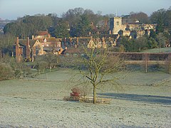
 Ewelme village seen from the south | |
Location within Oxfordshire | |
| Area | 11.50 km2 (4.44 sq mi) |
| Population | 1,048 (2011 Census) |
| • Density | 91/km2 (240/sq mi) |
| OS grid reference | SU6491 |
| District | |
| Shire county | |
| Region | |
| Country | England |
| Sovereign state | United Kingdom |
| Post town | Wallingford |
| Postcode district | OX10 |
| Dialling code | 01491 |
| Police | Thames Valley |
| Fire | Oxfordshire |
| Ambulance | South Central |
| UK Parliament | |
| Website | Ewelme community website |
Ewelme (/ˈjuːɛlm/) is a village and civil parish in the Chiltern Hills in South Oxfordshire, 2.5 miles (4 km) northeast of the market town of Wallingford. The 2011 census recorded the parish's population as 1,048.[1] To the east of the village is Cow Common and to the west, Benson Airfield, the northeastern corner of which is within the parish boundary. The local geology is chalk overlying gault clay; the drift geology includes some gravel.
- ^ "Area: Ewelme (Parish): Key Figures for 2011 Census: Key Statistics". Neighbourhood Statistics. Office for National Statistics. Retrieved 13 December 2014.
