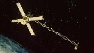
 Explorer 61 (Magsat) satellite | |
| Names | Explorer 61 Magsat-A AEM-C Applications Explorer Mission-C |
|---|---|
| Mission type | Space physics |
| Operator | NASA / USGS |
| COSPAR ID | 1979-094A |
| SATCAT no. | 11604 |
| Mission duration | 7.5 months (achieved) |
| Spacecraft properties | |
| Spacecraft | Explorer LXI |
| Spacecraft type | Magnetic field Satellite |
| Bus | Applications Explorer Mission |
| Manufacturer | Goddard Space Flight Center |
| Launch mass | 158 kg (348 lb) |
| Power | Solar panels and batteries |
| Start of mission | |
| Launch date | 30 October 1979, 14:16 UTC |
| Rocket | Scout G-1 (S-203C) |
| Launch site | Vandenberg, SLC-5 |
| Contractor | Vought |
| Entered service | 30 October 1979 |
| End of mission | |
| Decay date | 11 June 1980 |
| Orbital parameters | |
| Reference system | Geocentric orbit[1] |
| Regime | Low Earth orbit |
| Perigee altitude | 351.90 km (218.66 mi) |
| Apogee altitude | 578.40 km (359.40 mi) |
| Inclination | 96.80° |
| Period | 93.90 minutes |
| Instruments | |
| Scalar Magnetometer Vector Magnetometer | |
Magsat (Magnetic field Satellite, Applications Explorer Mission-C or AEM-C or Explorer 61) was a NASA / USGS (United States Geological Survey) spacecraft, launched on 30 October 1979. The mission was to map the Earth's magnetic field, the satellite had two magnetometers. The scalar (Cesium vapor) and vector magnetometers gave Magsat a capability beyond that of any previous spacecraft. Extended by a telescoping boom, the magnetometers were distanced from the magnetic field created by the satellite and its electronics. The satellite carried two magnetometers, a three-axis fluxgate magnetometer for determining the strength and direction of magnetic fields, and an ion-vapor/vector magnetometer for determining the magnetic field caused by the vector magnetometer itself.[2] Magsat is considered to be one of the more important Science/Earth-orbiting satellites launched; the data it accumulated is still being used, particularly in linking new satellite data to past observations.
- ^ Cite error: The named reference
Trajectorywas invoked but never defined (see the help page). - ^ "History of Vector Magnetometers in Space". Archived from the original on 20 May 2012. Retrieved 8 July 2008.