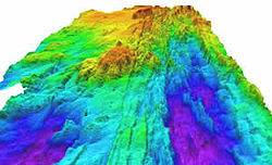


The Explorer Ridge is a mid-ocean ridge, a divergent tectonic plate boundary located about 241 km (150 mi) west of Vancouver Island, British Columbia, Canada. It lies at the northern extremity of the Pacific spreading axis. To its east is the Explorer plate, which together with the Juan de Fuca plate and the Gorda plate to its south, is what remains of the once-vast Farallon plate which has been largely subducted under the North American plate. The Explorer Ridge consists of one major segment, the Southern Explorer Ridge, and several smaller segments. It runs northward from the Sovanco Fracture Zone to the Queen Charlotte triple junction, a point where it meets the Queen Charlotte Fault and the northern Cascadia subduction zone.