| Expressways of Singapore 新加坡高速公路 Rangkaian Lebuhraya Singapura | |
|---|---|
 Symbol of the Singaporean expressways | |
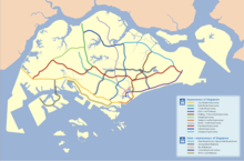
 Map of the Singaporean expressway network as of 2012 | |
| System information | |
| Maintained by Land Transport Authority (LTA) | |
| Length | 163 km (101 mi) |
| Formed | 1966 |
| Highway names | |
| Expressways | Expressway AAA (AAA) |
| System links | |


The expressways of Singapore are special roads that allow motorists to travel quickly from one urban area to another. Construction of the system was authorized when construction of the Pan Island Expressway began in 1962. All of them are dual carriageways with grade-separated access. They usually have three to four lanes in each direction, although there are two-lane carriageways at many expressway intersections and five-lane carriageways in some places. There are currently ten expressways and studies about the feasibility of more are ongoing.
Construction on the first expressway, the Pan Island Expressway, started in 1966. As of 2014[update], there are 163 kilometres (101 mi) of expressways in Singapore.[1]
The Singaporean expressway networks are connected with Malaysian expressway networks via Ayer Rajah Expressway (connects with the Second Link Expressway in Malaysia) and Bukit Timah Expressway (connects with the Johor Bahru Eastern Dispersal Link Expressway via Johor–Singapore Causeway).
- ^ "Expressways in Singapore: Did you know?". The Highway. Automobile Association of Singapore. July 2001. Archived from the original on 10 March 2006. Retrieved 5 April 2006.