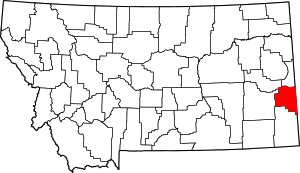
Fallon County | |
|---|---|
 Fallon County Courthouse in Baker | |
 Location within the U.S. state of Montana | |
 Montana's location within the U.S. | |
| Coordinates: 46°21′N 104°25′W / 46.35°N 104.41°W | |
| Country | |
| State | |
| Founded | December 9, 1913 |
| Seat | Baker |
| Largest city | Baker |
| Area | |
| • Total | 1,623 sq mi (4,200 km2) |
| • Land | 1,621 sq mi (4,200 km2) |
| • Water | 2.3 sq mi (6 km2) 0.1% |
| Population (2020) | |
| • Total | 3,049 |
| • Estimate (2022) | 3,011 |
| • Density | 1.9/sq mi (0.73/km2) |
| Time zone | UTC−7 (Mountain) |
| • Summer (DST) | UTC−6 (MDT) |
| Congressional district | 2nd |
| Website | www |
| |
Fallon County is a county located in the U.S. state of Montana. As of the 2020 census, the population was 3,049.[1] Its county seat is Baker.[2] The county was created in 1913 from a portion of Custer County. It is named for Benjamin O'Fallon, a nephew of Captain William Clark and an Indian agent for the upper Missouri region from 1823 to 1827.[3]
- ^ "State & County QuickFacts". United States Census Bureau. Retrieved May 9, 2023.
- ^ "Find a County". National Association of Counties. Archived from the original on May 31, 2011. Retrieved June 7, 2011.
- ^ "Montana Place Names Companion". Montana Place Names From Alzada to Zortman. Montana Historical Society Research Center. Retrieved May 9, 2011.