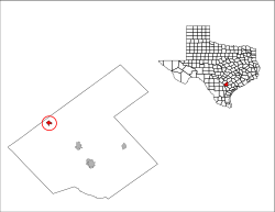
Falls City, Texas | |
|---|---|
 Location of Falls City, Texas | |
 | |
| Coordinates: 28°59′N 98°1′W / 28.983°N 98.017°W | |
| Country | United States |
| State | Texas |
| County | Karnes |
| Area | |
• Total | 0.91 sq mi (2.36 km2) |
| • Land | 0.89 sq mi (2.31 km2) |
| • Water | 0.02 sq mi (0.05 km2) |
| Elevation | 308 ft (94 m) |
| Population (2020) | |
• Total | 514 |
| • Density | 772.42/sq mi (298.18/km2) |
| Time zone | UTC-6 (Central (CST)) |
| • Summer (DST) | UTC-5 (CDT) |
| ZIP code | 78113 |
| Area code | 830 |
| FIPS code | 48-25392[2] |
| GNIS feature ID | 1357209[3] |
Falls City is a city in Karnes County, Texas, United States. The population was 514 at the 2020 census.[4] Falls City is near the location of a uranium tailings disposal cell, completed in 1994 under the terms of the 1978 Uranium Mill Tailings Radiation Control Act.[5] The early settlers, predominantly Polish Catholics, founded the Holy Trinity Catholic Church in 1902.
- ^ "2019 U.S. Gazetteer Files". United States Census Bureau. Retrieved August 7, 2020.
- ^ "U.S. Census website". United States Census Bureau. Retrieved January 31, 2008.
- ^ "US Board on Geographic Names". United States Geological Survey. October 25, 2007. Retrieved January 31, 2008.
- ^ "Geographic Identifiers: 2010 Census Summary File 1 (G001), Falls City city, Texas". American FactFinder. U.S. Census Bureau. Archived from the original on February 13, 2020. Retrieved April 17, 2019.
- ^ "Falls City, Texas, Disposal Site Fact Sheet" (PDF). U.S. Department of Energy. April 5, 2009. Archived from the original (PDF) on April 6, 2021. Retrieved November 9, 2009.