This article needs additional citations for verification. (January 2024) |
Falls Mills, Virginia | |
|---|---|
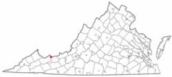
 Location in the Commonwealth of Virginia | |
| Coordinates: 37°27′56″N 81°31′14″W / 37.46556°N 81.52056°W | |
| Country | United States |
| State | Virginia |
| County | Tazewell |
| Area | |
| • Total | 0.89 sq mi (2.3 km2) |
| • Land | 0.878 sq mi (2.27 km2) |
| • Water | 0.012 sq mi (0.03 km2) 1.348% |
| Elevation | 2,858 ft (871.118 m) |
| Population (2020) | |
| • Total | 305 |
| Time zone | UTC-5 (EST) |
| • Summer (DST) | UTC-4 (EDT) |
| ZIP code | 24613 |
| Area code | 276 |
Falls Mills is an unincorporated community and census-designated place along Virginia State Route 102 in Tazewell County, Virginia, United States and is located at the mouth of the valley of Mud Fork creek. It is part of the Bluefield, WV-VA micropolitan area, which has a population of 107,578.