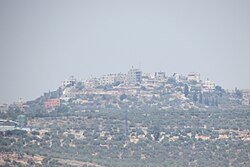
Far'ata | |
|---|---|
| Arabic transcription(s) | |
| • Arabic | فرعتا |
| • Latin | Far'ata (unofficial) |
 Far'ata | |
Location of Fara'ata within Palestine | |
| Coordinates: 32°11′26″N 35°09′57″E / 32.19056°N 35.16583°E | |
| Palestine grid | 165/177 |
| State | State of Palestine |
| Governorate | Qalqilya |
| Government | |
| • Type | Local Development Committee |
| Elevation | 432−518 m (−1,267 ft) |
| Population (2017)[2] | |
| • Total | 872 |
| Name meaning | Ferata, p.n.[3] |
Far'ata (Arabic: فرعتا) was a Palestinian village in the Qalqilya Governorate in the Western area of the West Bank, located 16 kilometers Southwest of Nablus. According to the Palestinian Central Bureau of Statistics, the village had a population of 872 inhabitants in 2017.[2]
In 2012 Fara'ata was merged with the larger Immatain village council.[1]
- ^ a b Immatin Village Profile (including Far’ata Locality), ARIJ, p. 4
- ^ a b Preliminary Results of the Population, Housing and Establishments Census, 2017 (PDF). Palestinian Central Bureau of Statistics (PCBS) (Report). State of Palestine. February 2018. pp. 64–82. Retrieved 2023-10-24.
- ^ Palmer, 1881, p. 182
