Farmington, Maine | |
|---|---|
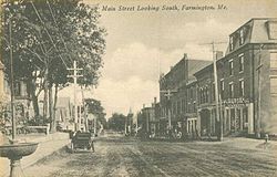
 Main Street | |
| Coordinates: 44°40′12″N 70°8′47″W / 44.67000°N 70.14639°W | |
| Country | United States |
| State | Maine |
| County | Franklin |
| Town | Farmington |
| Area | |
• Total | 4.04 sq mi (10.48 km2) |
| • Land | 4.04 sq mi (10.45 km2) |
| • Water | 0.01 sq mi (0.03 km2) |
| Elevation | 413 ft (126 m) |
| Population (2020) | |
• Total | 4,168 |
| • Density | 1,032.96/sq mi (398.79/km2) |
| Time zone | UTC-5 (Eastern (EST)) |
| • Summer (DST) | UTC-4 (EDT) |
| ZIP code | 04938 |
| Area code | 207 |
| FIPS code | 23-24740 |
| GNIS feature ID | 0566054 |
Farmington is a census-designated place (CDP) comprising the center of the town of Farmington, which is the county seat of Franklin County in Maine, United States. The population of the CDP was 4,288 at the 2010 census,[2] out of 7,760 people in the town as a whole. The University of Maine at Farmington is located within the CDP.
- ^ "2020 U.S. Gazetteer Files". United States Census Bureau. Retrieved April 8, 2022.
- ^ "Geographic Identifiers: 2010 Census Summary File 1 (G001), Farmington CDP, Maine". American FactFinder. U.S. Census Bureau. Archived from the original on February 13, 2020. Retrieved May 26, 2016.
