| Farnborough | |
|---|---|
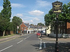
 Farnborough High Street with its village sign | |
Location within Greater London | |
| Population | 14,632 (2011 Census. Farnborough and Crofton Ward)[1] |
| OS grid reference | TQ445645 |
| • Charing Cross | 13.4 mi (21.6 km) NW |
| London borough | |
| Ceremonial county | Greater London |
| Region | |
| Country | England |
| Sovereign state | United Kingdom |
| Post town | ORPINGTON |
| Postcode district | BR6 |
| Dialling code | 01689 |
| Police | Metropolitan |
| Fire | London |
| Ambulance | London |
| UK Parliament | |
| London Assembly | |
Farnborough is a village in Greater London, England. Situated south of Locksbottom, west of Green Street Green, north of Downe and Hazelwood, and east of Keston, it is centred 13.4 miles (21.6 km) southeast of Charing Cross.
Suburban development following the Second World War resulted in the area becoming almost contiguous with the Greater London conurbation, but the village is still surrounded by open farmland. The area has formed part of the London Borough of Bromley local authority district since the formation of the ceremonial county of Greater London for administrative purposes in 1965.
- ^ "Bromley Ward population 2011". Neighbourhood Statistics. Office for National Statistics. Retrieved 10 October 2016.
