CC20
Farrer Road 花拉路 ஃபேரர் சாலை | |||||||||||
|---|---|---|---|---|---|---|---|---|---|---|---|
| Mass Rapid Transit (MRT) station | |||||||||||
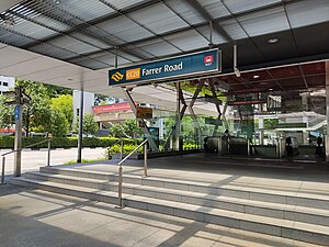
 Exit B of Farrer Road station | |||||||||||
| General information | |||||||||||
| Location | 71 Farrer Road Singapore 261006 | ||||||||||
| Coordinates | 1°19′02″N 103°48′27″E / 1.317319°N 103.807431°E | ||||||||||
| Operated by | SMRT Trains Ltd (SMRT Corporation) | ||||||||||
| Line(s) | |||||||||||
| Platforms | 2 (1 island platform) | ||||||||||
| Tracks | 2 | ||||||||||
| Connections | Bus, Taxi | ||||||||||
| Construction | |||||||||||
| Structure type | Underground | ||||||||||
| Platform levels | 1 | ||||||||||
| Accessible | Yes | ||||||||||
| History | |||||||||||
| Opened | 8 October 2011 | ||||||||||
| Electrified | Yes | ||||||||||
| Previous names | Farrer, Woollerton[1] | ||||||||||
| Passengers | |||||||||||
| June 2024 | 4,576 per day[2] | ||||||||||
| Services | |||||||||||
| |||||||||||
| |||||||||||
Farrer Road MRT station is an underground Mass Rapid Transit (MRT) station on the Circle line, located along the boundary of Farrer Court (Bukit Timah) and Tyersall (Tanglin) planning areas, Singapore. It is built underneath Farrer Road, the thoroughfare which gives the station its name, and is located near the Farrer Gardens Estate.
Farrer Road was named after Roland John Farrer, who was President of the Municipal Commissioners from 1919 to 1931. To avoid confusion with Farrer Park MRT station, the station was renamed to Farrer Road on 11 January 2007. The station serves the nearby Farrer Gardens housing estate, many condominiums and private homes, schools, and places of worship.
Farrer Road station is built underneath its namesake road, between the junctions of Empress Road and Woollerton Park.
- ^ "FINALISED NAMES FOR CIRCLE LINE (CCL) STAGES 4&5 STATIONS". www.lta.gov.sg. Archived from the original on 18 December 2006.
- ^ "Land Transport DataMall". Datamall. Land Transport Authority. Archived from the original on 14 August 2024. Retrieved 14 August 2024.
