Farsund | |
|---|---|
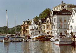
 View of the town | |
| Coordinates: 58°05′41″N 06°48′16″E / 58.09472°N 6.80444°E | |
| Country | Norway |
| Region | Southern Norway |
| County | Agder |
| District | Lister |
| Municipality | Farsund |
| Established as | |
| Ladested | 1795 |
| Area | |
| • Total | 2.96 km2 (1.14 sq mi) |
| Elevation | 4 m (13 ft) |
| Population (2019)[1] | |
| • Total | 9,924 |
| • Density | 1,140/km2 (3,000/sq mi) |
| Time zone | UTC+01:00 (CET) |
| • Summer (DST) | UTC+02:00 (CEST) |
| Post Code | 4550 Farsund |
is the administrative centre of Farsund municipality in Agder county, Norway. The town is located near the mouth of the Lyngdalsfjorden, about 5 kilometres (3.1 mi) east of the village of Vanse.[3] Frelserens Church is the main church for the town. The 2.96-square-kilometre (730-acre) town has a population (2019) of 3,377 and a population density of 1,140 inhabitants per square kilometre (3,000/sq mi).[1] In Norway, Farsund is considered a by which can be translated as either a "town" or "city" in English.
- ^ a b c Statistisk sentralbyrå (1 January 2019). "Urban settlements. Population and area, by municipality".
- ^ "Farsund, Vest-Agder". yr.no. Archived from the original on 2016-10-02. Retrieved 2016-10-01.
- ^ Store norske leksikon. "Farsund – tettstedet" (in Norwegian). Retrieved 2016-10-01.

