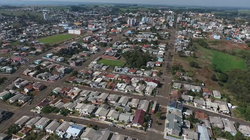
Faxinal dos Guedes | |
|---|---|
| City of Faxinal dos Guedes | |
 Clockwise from top: Panoramic view of the city center; Mother Church; Ipês in Av. Rio Grande do Sul; Plaza Ventura Migliorini and partial view of downtown. | |
 Location in the state of Santa Catarina | |
| Coordinates: 26°53′S 52°14′W / 26.883°S 52.233°W | |
| Country | |
| Region | South |
| State | Santa Catarina |
| Mesoregion | West of Santa Catarina |
| Government | |
| • Type | Mayor-council |
| Area | |
• Total | 105 sq mi (273 km2) |
| Elevation | 3,297 ft (1,005 m) |
| Population (2022 [1]) | |
• Total | 11,192 |
| • Density | 81.3/sq mi (31.38/km2) |
| Time zone | UTC -3 |
| Postal Code (CEP) | 89694-000 |
| Area code | (+55) 49 |
| Website | http://www.faxinal.sc.gov.br/ |
Faxinal dos Guedes is a municipality located in the west of the state of Santa Catarina, in the South Region of Brazil. Its population, according to the 2022 Brazilian Institute of Geography and Statistics Census, was 11 192 inhabitants.[2] With an area of 340,070 km2, part of its territory is located on the western edge of a meteoritic crater, the Vargeão Dome.[3]
It is one of the highest altitude cities in the state of Santa catarina, with its urban area having peaks of up to 3297,244 ft (1.005 m). Because of this, it bears the title of Capital of the Winds.[4][5][6]
It is located in the Immediate Geographical Region of Xanxerê and in the Intermediate Geographical Region of Chapecó. It is in the expansive area of the Metropolitan Region of Chapecó and at 307 miles away from the capital of Santa Catarina, Florianópolis.
With a high index of human development, the city is a highlight in the national scenario because it is the only one in the entire southern region of Brazil to have basic sanitation services serving 100% of the urban area besides having almost all of its asphalted streets.
Its economy is based on industry, with emphasis on the production of paper and packaging, and on the agricultural sector, with emphasis on the production of corn and soy.[7][8][9]
- ^ "Index of /Censos/Censo_Demografico_2022/Populacao_e_domicilios_Primeiros_resultados".
- ^ "Index of /Censos/Censo_Demografico_2022/Populacao_e_domicilios_Primeiros_resultados". ftp.ibge.gov.br. Retrieved 2023-09-13.
- ^ Kazzuo-Vieira, César; Crósta, Alvaro Penteado; Gamboa, Fernando; Tygel, Martin (September 2009). "Caracterização geofísica da estrutura de impacto do domo de Vargeão, Brasil". Revista Brasileira de Geofísica (in Portuguese). 27 (3): 375–388. doi:10.1590/S0102-261X2009000300006. ISSN 0102-261X.
- ^ Tecnológicas, Core Soluções. "Turismo de Faxinal dos Guedes deve ser explorado pela secretaria de Administração e Fazenda". Lance Notícias Faxinal. Retrieved 2023-09-13.
- ^ "Início". Prefeitura de Faxinal dos Guedes (in Brazilian Portuguese). Retrieved 2023-09-13.
- ^ "Divisão Territorial do Brasil" (in Portuguese). Divisão Territorial do Brasil e Limites Territoriais, Instituto Brasileiro de Geografia e Estatística (IBGE). July 1, 2008. Retrieved December 17, 2009.
- ^ "Estimativas da população para 1º de julho de 2009" (PDF) (in Portuguese). Estimativas de População, Instituto Brasileiro de Geografia e Estatística (IBGE). August 14, 2009. Retrieved December 17, 2009.
- ^ "Ranking decrescente do IDH-M dos municípios do Brasil" (in Portuguese). Atlas do Desenvolvimento Humano, Programa das Nações Unidas para o Desenvolvimento (PNUD). 2000. Archived from the original on October 3, 2009. Retrieved December 17, 2009.
- ^ "Produto Interno Bruto dos Municípios 2002-2005" (PDF) (in Portuguese). Instituto Brasileiro de Geografia e Estatística (IBGE). December 19, 2007. Archived from the original (PDF) on October 2, 2008. Retrieved December 17, 2009.

