This article needs additional citations for verification. (July 2014) |
| Felpham | |
|---|---|
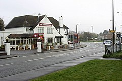
 The B2259/B2132 junction | |
Location within West Sussex | |
| Area | 4.26 km2 (1.64 sq mi) [1] |
| Population | 9,746 (2011)[2] |
| • Density | 2,255/km2 (5,840/sq mi) |
| OS grid reference | SZ949998 |
| • London | 54 miles (87 km) NNE |
| Civil parish |
|
| District | |
| Shire county | |
| Region | |
| Country | England |
| Sovereign state | United Kingdom |
| Post town | BOGNOR REGIS |
| Postcode district | PO22 |
| Dialling code | 01243 |
| Police | Sussex |
| Fire | West Sussex |
| Ambulance | South East Coast |
| UK Parliament | |
| Website | http://www.felphampc.gov.uk/ |
Felpham (/ˈfelpəm/,[3] sometimes pronounced locally as Felf-fm or Fel-thm) is a village and civil parish in the Arun District of West Sussex, England. Although sometimes considered part of the urban area of greater Bognor Regis, it is a village and civil parish in its own right, having an area of 1.645 square miles, (4.26 km),2 with a population of 9,611 people that is still growing (2001 census). The population at the 2011 Census was 9,746.[2]
Felpham lies on the B2259 coastal road.
The 12th century Anglican parish church is dedicated to the Virgin Mary.[4] There is also a Methodist church close to the three-way junction of Felpham Way, Flansham Lane and Middleton Road, in the east of the village.
- ^ "2001 Census: West Sussex – Population by Parish" (PDF). West Sussex County Council. Archived from the original (PDF) on 8 June 2011. Retrieved 26 March 2009.
- ^ a b "Civil Parish population 2011". Neighbourhood Statistics. Office for National Statistics. Archived from the original on 4 March 2016. Retrieved 13 October 2015.
- ^ Jones, Daniel (2011), Roach, Peter; Setter, Jane; Esling, John (eds.), Cambridge English Pronouncing Dictionary (18 ed.), Cambridge University Press, p. 185, ISBN 978-0-521-76575-6
- ^ Nairn, Ian; Pevsner, Nikolaus (1965). The Buildings of England: Sussex. Harmondsworth: Penguin Books. p. 219. ISBN 0-14-071028-0.
