Fereej Al Soudan
فريج السودان | |
|---|---|
District | |
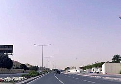
 Al Bustan Street in Fereej Al Soudan | |
| Coordinates: 25°16′26″N 51°28′44″E / 25.27389°N 51.47889°E | |
| Country | |
| Municipality | Al Rayyan |
| Zone | Zone 54, Zone 55 |
| District no. | 79 |
| Area | |
| • Total | 3.5 km2 (1.4 sq mi) |
| Elevation | 23 m (75 ft) |
Fereej Al Soudan (Arabic: فريج السودان, romanized: Farīj as-Sūdān) is a district in Qatar, located in the municipality of Al Rayyan.[3][4] It is mainly a residential area. In the 2015 census, it was listed as a district of Zone 55 which has a population of 283,675 and also includes Bu Sidra, Al Aziziya, Al Waab, New Fereej Al Ghanim, Muaither, Al Mearad, Fereej Al Manaseer, Fereej Al Murra and Al Sailiya. It is also listed as a district of Zone 54.[3]
It borders Al Waab district to the south and Fereej Al Nasr and Al Sadd districts in Doha to the east.[5] The district is connected to Al Waab through Al Waab Street, and both districts are being jointly developed as part of the Fereej Al Soudan District Centre plan. Furthermore, the District Centre will be complemented by infrastructure built in the neighboring Al Rayyan South Metropolitan Centre and Al Sadd Town Centre.[6]
- ^ "District Area Map". Ministry of Development Planning and Statistics. Retrieved 12 February 2019.
- ^ "Fereej Al Soudan 54, Zone 54, Qatar on the Elevation Map". elevationmap.net. Retrieved 2 January 2019.
- ^ a b "2015 population census" (PDF). Ministry of Development Planning and Statistics. Archived from the original (PDF) on 14 February 2017. Retrieved 1 January 2019.
- ^ "District map". The Centre for Geographic Information Systems of Qatar. Archived from the original on 24 November 2020. Retrieved 1 January 2019.
- ^ "Fereej Al Soudan (54)". qa.geoview.info. Retrieved 1 January 2019.
- ^ Cite error: The named reference
creportwas invoked but never defined (see the help page).
