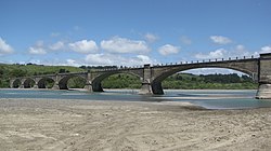
Fernbridge | |
|---|---|
 Partial view of the west side of Fernbridge as seen from the south bank of the Eel River | |
| Coordinates | 40°36′51″N 124°12′8″W / 40.61417°N 124.20222°W |
| Carries | |
| Crosses | Eel River |
| Locale | Fernbridge, California |
| Other name(s) | originally Eel River Bridge |
| Maintained by | California Department of Transportation |
| Characteristics | |
| Design | Arch bridge |
| Material | Concrete |
| Total length | 1,320 ft (402.3 m) |
| No. of spans | 7 |
| Piers in water | 8 during periods of high water |
| No. of lanes | 2 |
| History | |
| Designer | John B. Leonard |
| Constructed by | Pacific Construction (of San Francisco) |
| Construction start | 1910 |
| Opened | November 8, 1911 |
Fernbridge | |
| Area | 1.4 acres (0.6 ha) |
| NRHP reference No. | 87000566[1] |
| Added to NRHP | April 2, 1987 |
| Location | |
 | |
Fernbridge, originally Eel River Bridge,[2] is a 1,320-foot-long (402.3 m) concrete arch bridge designed by American engineer John B. Leonard which opened on November 8, 1911[3] at the site of an earlier ferry crossing of the Eel River. Fernbridge is the last crossing before the Eel arrives at the Pacific Ocean, and anchors one end of California State Route 211 leading to Ferndale, California. When built, it was referred to as the "Queen of Bridges" and is still the longest functional poured concrete bridge in operation in the world.[4]
- ^ "National Register Information System". National Register of Historic Places. National Park Service. March 13, 2009.
- ^ Ring, Ross (2023–2024). Titus, Caroline (ed.). "The Queen of Bridges welcomes visitors to The Victorian Village". The Ferndale Enterprise (Souvenir ed.). Ferndale, California: Cage Publishing, Incorporated. p. 15.
- ^ Pence, Steven (March 21, 2024). Greenson, Thadeus (ed.). "Caltrans to Install Seismic Gates on Fernbridge". The Ferndale Enterprise. Eureka, California: North Coast Journal Incorporated. pp. 1, 2.
- ^ "California 211". AA Roads. Retrieved December 24, 2012.