| Fernie Formation | |
|---|---|
| Stratigraphic range: Jurassic ~ | |
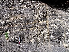
 Fernie Formation shale exposed in a roadcut near Sparwood, British Columbia | |
| Type | Geological formation |
| Sub-units | Nordegg Member, Red Deer Member, Poker Chip Shale, Lille Member, Rock Creek Member, Highwood Member, Pigeon Creek Member, Ribbon Creek Member |
| Underlies | Morrissey Formation, Nikanassin Formation, Monteith Formation |
| Overlies | Schooler Creek Group, Montney Formation, Rundle Group |
| Thickness | up to 400 metres (1,310 ft)[1] |
| Lithology | |
| Primary | Shale |
| Other | Sandstone, siltstone, limestone |
| Location | |
| Coordinates | 49°33′N 115°10′W / 49.55°N 115.16°W |
| Region | |
| Country | |
| Type section | |
| Named for | Fernie, British Columbia |
| Named by | W.W. Leach |
| Year defined | 1914 |
The Fernie Formation is a stratigraphic unit of Jurassic age. It is present in the western part of the Western Canada Sedimentary Basin in western Alberta and northeastern British Columbia.[2][3][4] It takes its name from the town of Fernie, British Columbia, and was first defined by W.W. Leach in 1914.[5]
- ^ Lexicon of Canadian Geologic Units. "Fernie Formation". Archived from the original on 2013-02-21. Retrieved 2009-02-10.
- ^ Mossop, G.D. and Shetsen, I. (compilers), Canadian Society of Petroleum Geologists and Alberta Geological Survey (1994). "The Geological Atlas of the Western Canada Sedimentary Basin, Chapter 18: Jurassic and Lowermost Cretaceous strata of the Western Canada Sedimentary Basin". Retrieved 2016-06-20.
{{cite web}}: CS1 maint: multiple names: authors list (link) - ^ Poulton, T.P., Tittemore, J. and Dolby, G. 1990. Jurassic strata of northwestern (and west-central) Alberta and northeastern British Columbia. Bulletin of Canadian Petroleum Geology 38A: 159-175.
- ^ Cite error: The named reference
Stott98was invoked but never defined (see the help page). - ^ Leach, W.W., 1914. Blairmore map-area, Alberta; Geological Survey of Canada, Summary Report 1912, p. 234. with Map 107A, Blairmore, Alberta, Scale: 1 inch to 2 miles

