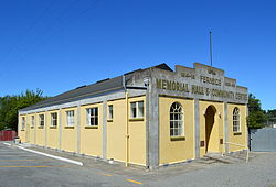
Fernside | |
|---|---|
 Memorial hall and community centre | |
 | |
| Coordinates: 43°19′S 172°32′E / 43.31°S 172.54°E | |
| Country | New Zealand |
| Region | Canterbury |
| Territorial authority | Waimakariri District |
| Ward | Rangiora-Ashley Ward |
| Community | Rangiora-Ashley Community |
| Electorates |
|
| Government | |
| • Territorial Authority | Waimakariri District Council |
| • Regional council | Environment Canterbury |
| • Mayor of Waimakariri | Dan Gordon |
| • Waimakariri MP | Matthew Doocey |
| • Te Tai Tonga MP | Tākuta Ferris |
| Area | |
• Total | 39.03 km2 (15.07 sq mi) |
| Population (June 2024)[2] | |
• Total | 1,420 |
| • Density | 36/km2 (94/sq mi) |
| Time zone | UTC+12 (NZST) |
| • Summer (DST) | UTC+13 (NZDT) |
| Postcode | 7471 |
| Area code | 03 |
| Local iwi | Ngāi Tahu |
Fernside is a small rural community in the Waimakariri District, New Zealand. In 1901, Fernside had (with its neighbourhood) a population of 550.[3] As of the 2006 New Zealand census, Fernside has a population of 1491.[4]
- ^ Cite error: The named reference
Areawas invoked but never defined (see the help page). - ^ "Aotearoa Data Explorer". Statistics New Zealand. Retrieved 26 October 2024.
- ^ "FERNSIDE". THE CYCLOPEDIA OF NEW ZEALAND. Retrieved 29 November 2013.
- ^ "Interactive Boundary Maps". Statistics New Zealand. Archived from the original on 30 October 2013. Retrieved 29 November 2013.