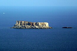
Native name: Filfa | |
|---|---|
 Filfla and neighboring Filfoletta seen from Dingli Cliffs (from northwest) | |
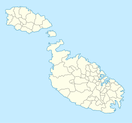
 Map of Filfla | |
| Geography | |
| Location | South of Malta, Mediterranean Sea |
| Coordinates | 35°47′15″N 14°24′37″E / 35.78750°N 14.41028°E |
| Archipelago | Maltese islands |
| Total islands | 2 |
| Area | 0.06 km2 (0.023 sq mi) |
| Highest elevation | 60 m (200 ft) |
| Administration | |
Malta | |
| Demographics | |
| Population | 0 |
Filfla is a mostly barren, uninhabited islet 4.5 kilometres (2.8 miles) south of Malta, and is the most southerly point of the Maltese Archipelago. Filflu (or Filfluu), a rocky islet some 101 metres (331 feet) southwest of Filfla,[1] has the southernmost point of Malta. The name is believed to come from felfel, the Arabic for a peppercorn.[2]
- ^ "Topography and Flora of the Satellite islets surrounding the Maltese Archipelago" - Arnold Sciberras, Jeffrey Sciberras, 2010
- ^ Morana, Martin (2011). Bejn Kliem u Storja (in Maltese). Malta: Books Distributors Limited. ISBN 978-99957-0137-6. Archived from the original on 20 October 2016.
