Financial District | |
|---|---|
 View of the Financial District from the north east at the Pantages Tower | |
 | |
| Coordinates: 43°38′52.565″N 79°22′54.308″W / 43.64793472°N 79.38175222°W | |
| Country | |
| Province | |
| City | Toronto |
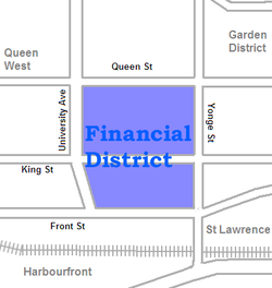
The Financial District is the central business district of Downtown Toronto, Ontario, Canada. It was originally planned as New Town in 1796 as an extension of the Town of York (later the St. Lawrence Ward).[1] It is the main financial district in Toronto and is considered the heart of Canada's finance industry. It is bounded roughly by Queen Street West to the north, Yonge Street to the east, Front Street to the south, and University Avenue to the west, though many office towers in the downtown core have been and are being constructed outside this area, which will extend the general boundaries. Examples of this trend are the Telus Harbour, RBC Centre, and CIBC Square.
It is the most densely built-up area of Toronto, home to banking companies, corporate headquarters, high-powered legal and accounting firms, insurance companies and stockbrokers. In turn, the presence of so many decision-makers has brought advertising agencies and marketing companies. The banks have built large office towers, much of whose space is leased to these companies.
The bank towers and much else in Toronto's core are connected by a system of underground walkways, known as PATH, which is lined with retail establishments making the area one of Toronto's most important shopping districts. The vast majority of these stores are only open during weekdays during the business day when the financial district is populated. During the evenings and weekends, the walkways remain open but the area is almost deserted and most of the stores are closed.
It is estimated 100,000 commuters enter and leave the financial district each working day. Transport links are centred on Union Station at the south end of the financial district, which is the hub of the GO Transit system that provides commuter rail and bus links to Toronto's suburbs.
- ^ Historical Atlas of Toronto, Derek Hayes, 2008, ISBN 978-1-55365-290-8, Pg 26
