| Finn River | |
|---|---|
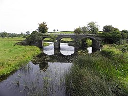
 The south-western stretch of the Finn River flowing under Annaghraw Railway Bridge, as photographed from Annaghmullin Bridge. County Fermanagh is on the left, while County Monaghan is on the right. | |
 | |
| Etymology | Irish: Finn, meaning 'Fair, Clear One', 'Bright One' |
| Native name | Abhainn na Finne (Irish) |
| Location | |
| Jurisdictions | Northern Ireland and the Republic of Ireland |
| Province | Ulster |
| Counties | County Fermanagh, County Monaghan and County Cavan |
| Physical characteristics | |
| Source | |
| • location | Knoppane, a hill just north-west of Roslea in the south-east of County Fermanagh |
| Mouth | |
• location | Derrykerrib, near Wattlebridge, on Upper Lough Erne |
• coordinates | 54°08′30″N 7°22′18″W / 54.1417°N 7.3716°W |
| Basin features | |
| River system | Erne |
| Tributaries | |
| • right | Lackey River, which flows into the Finn just east of Annies Bridge |
The Finn River (Irish: An Fhinn or Abhainn na Finne), also known as the River Finn, is a small river that flows through parts of County Fermanagh and parts of County Monaghan in the south of Ulster, the northern province in Ireland.[1][2][3][4] In certain places, the river forms part of the boundary between County Fermanagh, which is part of Northern Ireland, and County Monaghan, which is part of the Republic of Ireland. Two very short stretches of the river, just north of Redhills and at Castle Saunderson, near Belturbet, also form part of the boundary between County Fermanagh and County Cavan (part of the Republic of Ireland).[3] This means that some stretches of the river form part of the border between Northern Ireland and the Republic of Ireland, these short stretches also forming part of the external border of the European Union.
Some stretches of the river flow entirely within County Fermanagh, while other stretches flow entirely within County Monaghan. The river eventually flows into Upper Lough Erne, entering the lough very near Castle Saunderson.[2][3] The Finn River should not be confused with the better known and much longer River Finn, which mainly flows through County Donegal in the west of Ulster.[5]
- ^ McNally, Frank. "Exploring the Border: A frontier marked by myriad crossings". The Irish Times.
- ^ a b "Coarse Fishing - Clones". Monaghan Tourism. Retrieved 29 August 2023.
- ^ a b c Discoverer Series Sheet 27 (F Edition). Ordnance Survey of Northern Ireland (O.S.N.I.), Land and Property Services, Belfast, 2019.
- ^ Discovery Series Sheet 28A (3rd Edition). Ordnance Survey of Ireland (O.S.I.), Dublin, 2012.
- ^ Patrick McKay, A Dictionary of Ulster Place-Names, p. 69. The Institute of Irish Studies, The Queen's University of Belfast, Belfast, 1999.