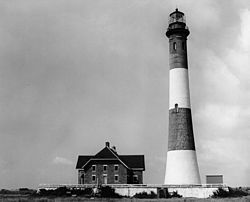
 Fire Island Lighthouse in December 2003 | |
 | |
| Location | Fire Island inlet, Long Island |
|---|---|
| Coordinates | 40°37′56.8″N 73°13′6.9″W / 40.632444°N 73.218583°W |
| Tower | |
| Constructed | 1826 |
| Foundation | Connecticut River Blue Stone and timber |
| Construction | Brick encased in cement |
| Automated | 1986 |
| Height | 168 feet (51 m) [1] |
| Shape | Conical tower |
| Markings | Four black and white bands |
| Heritage | National Register of Historic Places listed place |
| Light | |
| First lit | 1858 |
| Deactivated | Active, inactive 1974–1986 |
| Focal height | 55 m (180 ft) |
| Lens | First order Fresnel 1856 (original), Carlisle & Finch Company (current) |
| Range | 24 nautical miles (44 km; 28 mi) |
| Characteristic | Flashing White 7.5 seconds counterclockwise. |
Fire Island Light Station; Fire Island Light Station Historic District | |
 | |
| Nearest city | Kismet, New York |
| Area | 0.3 acres (0.12 ha) |
| Built | 1858 |
| Architect | Morton, J.T. |
| NRHP reference No. | 81000082[2] 09001288[3] |
| Added to NRHP | September 11, 1981; January 29, 2010 (boundary increase) |
The Fire Island Lighthouse is a visible landmark on the Great South Bay, in southern Suffolk County, New York on the western end of Fire Island, a barrier island off the southern coast of Long Island.[4][5] The lighthouse is located within Fire Island National Seashore and just to the east of Robert Moses State Park. It is part of the Fire Island Light Station which contains the light, keepers quarters, the lens building containing the original first-order Fresnel lens, and a boat house.
- ^ "Inventory of Historic Lighthouses". National Park Service. Retrieved 2007-08-14.
- ^ "National Register Information System". National Register of Historic Places. National Park Service. March 13, 2009.
- ^ "WEEKLY LIST OF ACTIONS TAKEN ON PROPERTIES: 1/25/10 THROUGH 1/29/10". National Register of Historic Places. National Park Service. 2010-02-05.
- ^ ARLHS World List of Lights
- ^ Rowlett, Russ. "Lighthouses of the United States: Long Island, New York". The Lighthouse Directory. University of North Carolina at Chapel Hill.