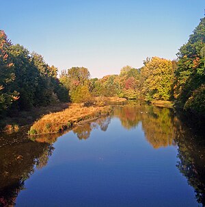
| Fishkill Creek | |
|---|---|
 Fishkill Creek from NY 52 near Brinckerhoff | |
 Fishkill Creek watershed | |
| Etymology | Dutch for "fish stream" |
| Native name | Matteawan [1] (Munsee) |
| Location | |
| Country | United States |
| State | New York |
| Region | Hudson Valley |
| County | Dutchess |
| Towns | Union Vale, Beekman, East Fishkill, Fishkill |
| Physical characteristics | |
| Source | Pray Pond |
| • coordinates | 41°40′38″N 73°40′38″W / 41.67722°N 73.67722°W |
| • elevation | 480 ft (150 m) |
| Mouth | Hudson River S of Denning Point |
• coordinates | 41°28′55″N 73°59′8″W / 41.48194°N 73.98556°W |
• elevation | 0 ft (0 m) |
| Length | 33.5 mi (53.9 km), SW |
| Basin size | 193 sq mi (500 km2) |
| Discharge | |
| • location | Beacon |
| • average | 205 cu ft/s (5.8 m3/s) |
| • minimum | 1.1 cu ft/s (0.031 m3/s)September 12, 1964 |
| • maximum | 6,970 cu ft/s (197 m3/s)August 20, 1955 |
| Discharge | |
| • location | Hopewell Junction |
| • average | 130 cu ft/s (3.7 m3/s) |
| • minimum | 25 cu ft/s (0.71 m3/s)1965 |
| • maximum | 140 cu ft/s (4.0 m3/s)1972 |
| Basin features | |
| Tributaries | |
| • left | Whaley Lake Brook, Clove Creek |
| • right | Whortlekill Creek, Sprout Creek |
Fishkill Creek (also Fish Kill, from the Dutch vis kille, for "fish creek") is a tributary of the Hudson River in Dutchess County, New York, United States. At 33.5 miles (53.9 km)[2] it is the second longest stream in the county, after Wappinger Creek. It rises in the town of Union Vale and flows generally southwest to a small estuary on the Hudson just south of Beacon. Part of its 193-square-mile (500 km2) watershed[3] is in Putnam County to the south. Sprout Creek, the county's third-longest creek, is its most significant tributary. Whaley and Sylvan lakes and Beacon Reservoir, its largest, deepest and highest lakes, are among the bodies of water within the watershed.
While the creek is not impounded for use in any local water supply, it remains a focus of regional conservation efforts as a recreational and aesthetic resource, especially since the lower Fishkill watershed has been extensively developed in the last two decades. It flows through several local parks and is a popular trout stream. Industries and mills along it helped spur the settlement of the region.
- ^ History of the Indian tribes of Hudson's River: their origin, manners and customs..., By Edward Manning Ruttenberg, page 370
- ^ U.S. Geological Survey. National Hydrography Dataset high-resolution flowline data. The National Map Archived 2012-03-29 at the Wayback Machine, accessed October 3, 2011
- ^ "Fishkill Creek Information". Dutchess Watersheds. 2009. Retrieved April 18, 2010.