| Fitzroy River | |
|---|---|
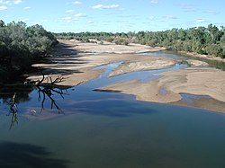
 Fitzroy River, looking north from bridge at Fitzroy Crossing | |
 | |
| Location | |
| Country | Australia |
| Physical characteristics | |
| Source | |
| • location | Wunaamin Miliwundi Ranges |
| • elevation | 486 metres (1,594 ft)[1] |
| Mouth | |
• location | King Sound |
| Length | 733 kilometres (455 mi)[2] |
| Basin size | 93,829 square kilometres (36,228 sq mi)[3] |
| Discharge | |
| • average | 84.78 cubic metres per second (2,994 cu ft/s)[4] |
The Fitzroy River, also known as Martuwarra, is located in the West Kimberley region of Western Australia. It has 20 tributaries and its catchment occupies an area of 93,829 square kilometres (36,228 sq mi), within the Canning Basin and the Timor Sea drainage division.
It often floods extensively during the wet season, and is known as the major remaining habitat for the critically endangered largetooth sawfish.
- ^ "Bonzle Digital Atlas – Map of Fitzroy River, WA". 2008. Retrieved 26 November 2008.
- ^ "History of river names – F". Western Australian Land Information Authority. Archived from the original on 19 April 2021. Retrieved 4 September 2011.
- ^ "Australian Natural Resources Atlas – Landscape – carbon, nutrients, water and productivity – Fitzroy River (WA)". 2008. Archived from the original on 4 August 2008. Retrieved 26 November 2008.
- ^ For station at Dimond Gorge